Hello friends, Welcome to another article, In this article we will learn how to use world smallest GPS and GNSS Module. and the module is RYS8830, which is sent to me by REYAX technology.
Whenever we make any project which required location, for example a tracking device , we often use NEO-6M GPS Module,
This module is good for retrieving location and date but the size of this module is not generous,
So we have restrictions over size, We can’t make our project as small as we want , to solve this problem Reyax has developed a new GPS and GNSS Module, which is way smaller than the NEO-6M GPS Module.
As you can see side by side comparison of both the module. These two module has good amount of size difference.
As you can see REYAX RYS8830 is very tiny and I can easily held in my finger tip.
And apart from the size, the power consumption of this module is also very low. due to its low power consumption and small form factor, we can use this module in lots of applications, like in wearable electronic devices, watches, hand-held devices.
Apart from this module we will also learn about its evolution development board. by using this evolution board we can directly connect GNSS Module to our computer.
And by doing this we can easily communicate with satellite systems.
Features & Specifications of RYS8830 GNSS Module.
The REYAX RYS8830 is built on the high performance of the SONY CXD5605GF GNSS engine.
And this modules utilize concurrent reception of GNSS systems which offers high sensitivity in a small SMD form factor.
This module occupies a small SMD size of 121 mm square , which currently is the smallest GNSS module worldwide along with an antenna.
The operating voltage is around 1.8volt. which is very less we can power up this module using any coin cell battery.
RYS8830 has a built-in enhanced GNSS filter, a low noise amplifier, an embedded antenna, and we have also option for external antenna. the tracking sensitivity is around -161 dBm.
The Navigation update rate of this module is 1 Hz and Accuracy is up to 1m and this is way more accurate than other GPS or GNSS module available in the market.
And the Operating Temperature is from -40°C to +85°C, so we could use this module in any Weather conditions it may be hot location or cold location.
And the Satellite acquisition Current is 19 mA and the Idle Current is 3 mA.
REYAX RYS8830 Evolution Board.
The RYS8830 GNSS/GPS Module is very small and has SMD form factor that it requires a PCB for experiments and learning, we can’t use this module as it.
To solve this problem REYAX team has design and developed the RYS8830 Evaluation Board.
This is the schematic of evolution board.
Click here to download the Gerber file of this evolution board.
After downloading the Gerber file , We gave its order directly to JLCPCB, now even you can try ordering your own custom PCBs from JLCPCB by following very simple steps.
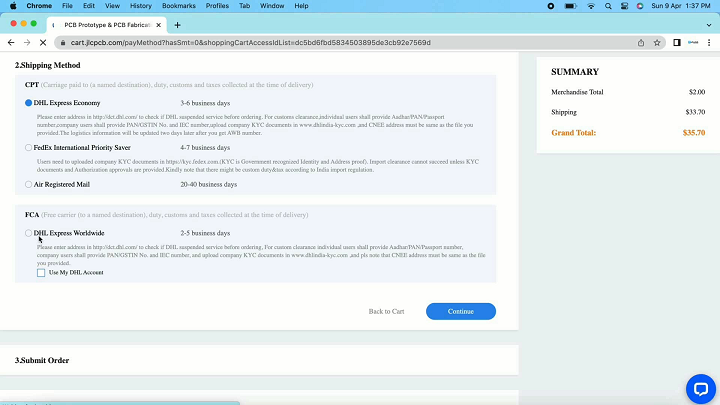
Ordering the PCBs at JLCPCB.
This project is sponsored by JLCPCB. JLCPCB is a full feature Printed Circuit Board manufacturing service.
Turn your DIY breadboard circuits into professional PCBs– get 10 boards for approximately $5 + shipping (which will vary depending on your country).
Once you have your Gerber files, you can order the PCB. Follow the next steps.
1. Download the Gerber files –click here to download the.zip file.
2. Go to JLCPCB website and Click on Quote Now button.
3.Upload the Gerber file you downloaded in the last step. Upload the.zip file or you can also drag and drop the Gerber files.
After uploading the zip file, you’ll see a success message at the bottom if the file is successfully uploaded. You can review the PCB in the Gerber viewer to make sure everything is good.
JLCPCB can grab all the PCB details and automatically fills them for you.
Select the PCB quantity and color masking of PCB by your self. I am selecting green color.
After that Click on Save to cart to complete your order.
And here if you select the fastest shipping option you may get the PCBs delivered at your desired location within a week.
So, finally we received our PCBs in a very good packaging within a week.
Do try Ordering the PCBs for your next projects from the JLCPCB & not only that,
JLCPCB also provides the PCB Assembly services and the 3D Printing services.
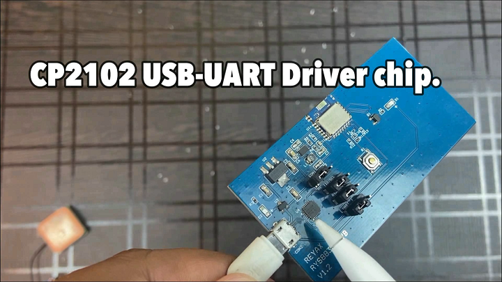
RYS8830 Evolution Board.
The evaluation board has jumpers for UART or I2C Interface.
It also has a reset button for resetting the board or restarting the module.
This evolution board consists of a CP2102 Chip which is a USB-UART Driver chip.
The micro-USB port can be used to connect the module directly to the computer and also the GNNS Software.
How can we use RYS8830 GNSS Module in Projects.
If you want to make any tracking device or any project that requires the coordinates of the location, In all that project we can use this module, and you can use this GNSS module with any of the microcontroller, I will be using Arduino Uno.
RYS8830 GNSS Module works at logic level 1.8volt and Arduino Uno works at 5volt logic level.
So we can not connect this GNSS module directly to the Arduino Uno. We need to convert the logic level of Arduino Uno’s 5volt into 1.8volt.
Here I am using UART Communication protocol, so we also need to convert the 1.8volt logic level into 5volt. That means we need bi-directional logic level converter,
Here I am using this High-Speed bi-directional 8-Channel Logic Level Converter.
This module is very good for bidirectional logic level converter.
And we can use this module in various logic level converter like 5 volt to 3.3 volt or 3.3volt to 1.8 volt or from 5volt into 1.8 volt.
If you need this module, you can purchase this module from our website, apart from this module we have other lot of useful and interesting products and modules.
technolab electronics.
Connection of REYAX RYS8830 With Arduino UNO and NodeMCU.
Connect the REYAX GNSS Module to the Arduino Uno using bidirectional logic level converter as per this circuit diagram.
If you want to use NodeMCU then you can use this circuit diagram for making connections.
I have connected the REYAX Evolution board to the Arduino Uno with logic level converter.
CODE.
This is code for retrieving latitude, longitude and date from the GNSS module.
Let me explain it for you.
First of all select the baud rate 115200 for the GNSS module and apart from this baud rate GNSS module not gonna work.
After that here in the setup part , these are the control commands to set and start the serial communication with satellite.
After that here we are encoding the GNSS data and calling a function displayinfo to print the Information, In case if GPS module is not connected properly then in that case we didn’t get any data , then a message will print on the serial monitor called ‘no gps detected check wiring’
The displayinfo function in which I am printing location that is latitude and longitude, if coordinates were not available it will print ‘invalid’. Similarly here it is printing date, received from GNSS module.
Now upload this code into your Arduino Uno board after selecting right board and right communication port. Once the code is successfully uploaded, open serial monitor.
Here as you can see location that is latitude and longitude is Printed here along with the date.
And these data are coming from the Satellite through Reyax GNSS module.
Let copy this coordinates and search on google if these coordinates are correct or not.
This is exact location of mine, the accuracy of the module is great.
GPS vs GNSS.
GPS that is Global Positioning System and GNSS that is Global Navigation Satellite System are both satellite-based navigation systems that can provide location, speed, and time information to users. Still , there are some differences between GPS and GNSS:
Number of Satellites: GPS is a specific navigation system operated by the United States government and uses a constellation of satellites orbiting the Earth. GNSS is a broader term that includes other satellite-based navigation systems such as GLONASS from Russia, Galileo from European Union, BeiDou from China, and other regional systems.
Coverage: GPS provides global coverage, but the accuracy may be affected in some regions due to signal obstructions or interference. GNSS, on the other hand, can provide more reliable and accurate location information in areas where GPS signals may be weak or obstructed.
Accuracy: Both GPS and GNSS can provide high-precision location information, but GNSS may offer better accuracy due to the availability of more satellites and advanced signal processing techniques.
Applications: GPS and GNSS are used in a wide range of applications such as navigation, surveying, mapping, geodesy, and more. GNSS can be particularly useful in applications that require high-precision location information, such as in aviation, agriculture, and construction.
If we conclude this , GPS is a specific navigation system operated by the United States, while GNSS is a broader term that includes other satellite-based navigation systems. While both systems share some similarities, GNSS can provide more reliable and accurate location information, particularly in areas where GPS signals may be weak or obstructed.